|
||||
|
10 Acres Near Crystalaire Country Club |
||||
|
|
 |
|||
 |
||||
 |
||||
 |
||||
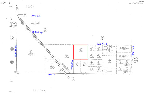
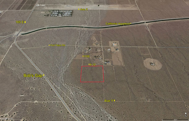
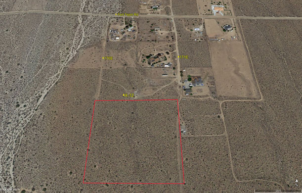
| Location- |
near 170th St East @ Ave X-12 | |
Area- |
Llano, east of Crystalaire County Club, a golf course community | |
Acres- |
10 net acres |
|
APNs- |
3061- 37- 4 |
|
Zoning- |
A 2 2, heavy agriculture, 1 home per 2 acres | |
Topography- |
flat & level | |
Dimensions- |
660’ x 660’ | |
Utilities- |
elec / tele on 171st St East | |
Price- |
$15,000 ($1,500 p/acre) | |
Existing Notes- |
free and clear | |
Terms- |
all cash | |
Remarks- |
Investor path of
growth parcel in the Llano area with 7 existing homes in area, on Fort
Tejon Rd. Zoning of A 2 2 allows for commercial solar farms as well as
horses and farm animals. Elec and tele are on 171st St East, very near
the NE corner of subject parcel. Area homes use well water and septic
systems. Nice views to north over the California Aqueduct. The golf course
community of Crystalaire is located located approximately 1/2 mile due
east. Pearblossom Hwy leads west back into Pearblossom, Littlerock, and
Palmdale; and east to Victorville and the Fwy 15. Parcel is flat and level.
Highest & best use: custom home site, farm, ranch, or hold for investment Buyer and buyer’s agent to verify all information provided herein by listing broker. |
|
Safety and Cautions- |
Anyone inspecting, or walking on the property, off the road, should be aware that rattlesnakes and other desert wild life could be in the area. Be careful and use common sense! | |
Directions to Property- |
From downtown
Palmdale, go east on Palmdale Blvd. to the rotary / traffic circle at
47th St East, staying to the right (south). Proceed south on 47th St East,
past Ave S, and stay on Pearblossom Hwy (138) which will bend to the left
(southeast). Stay on Pearblossom Hwy passing through the communities of
Littlerock and Pearblossom. When you leave Pearblossom you will be in
the area of 130th St East. Continue eastbound on Pearblossom Hwy (138).
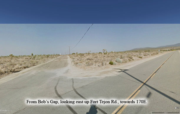
At 165th East, a paved road, turn right (south). Continue south on 165E
for 2.1 miles. At Fort Tejon Rd (dirt), turn left (east) and go 1/2 mile
to 170th St East. 170th East may not have a street sign. At 170th East,
turn right (south) and go 2/10 of a mile. Stop.
You are now at the NW corner of subject property. |
|